Geoconnex Explained: The Community Effort Powering the Internet of Water
Olivia Snavely, Strategic Communications Associate, Center for Geospatial Solutions
April 2024
Water data has a problem. With countless naming conventions and metadata standards, finding information about the right water feature (which of the four Illinois Rivers are you referring to?) much less all the data relevant to that feature is a job in and of itself. The Internet of Water aims to solve this challenge by connecting the data points and people of the water data community with a one shared language.
Geoconnex: The Water Data Discovery Solution
Enter Geoconnex: a universal system for tying water data back to an exact, real-world location that helps make finding the water data decision-makers need as simple as a Google search. Imagine the International Standard Book Number (ISBN) system, which identifies books by assigning a unique number ID to each variation of a publication. When every edition and print type of a single title has a unique ID, anyone can easily find the exact version of a text they’re looking for.
Geoconnex does the same for water features, enabling water data publishers to tie their data back to unique, persistent identifiers (PIDs) which represent every hydrological feature in the United States — every streamgage location, watershed, diversion, administrative boundary and more.
But unlike the ISBN system where each PID is a static serial number, Geoconnex PIDs are actual webpages that act as a one-stop reference for all the data that has been linked to that feature. Just like the countless websites that make up the world wide web, Geoconnex is bringing the Internet of Water to life by creating a living catalogue of national water features and their data.
By transforming how we collectively manage our shared water data, Geoconnex stands to radically improve how we manage our shared water resources with more accurate, efficient, and timely access to critical information. Now, we’re one step closer to this vision with support from a key new partner.

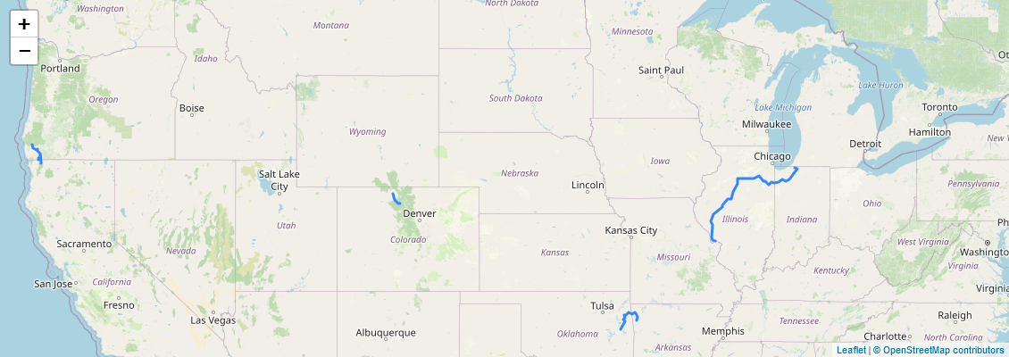
There are four different Illinois Rivers in the United States, as seen in Geoconnex.
Expanding Geoconnex for Wide Scale Adoption with Support from USGS
This spring, the Center for Geospatial Solutions, a co-leader of the Internet of Water Coalition and developer of the Geoconnex system, commenced a five-year, $2.5 million co-operative agreement with the United States Geological Survey (USGS) to scale up the Geoconnex technology.
This new collaboration marks the beginning of an exciting new phase of development for Geoconnex. While efforts to date have focused on back-end development of Geoconnex, this multi-year partnership crucially ensures a stable, long-term environment for Geoconnex to grow and thrive.
Once the initial development of Geoconnex is complete, with USGS support CGS will be able to continue growing the foundational software to meet community interests. From enriching the system with new data fields to monitoring adjacent infrastructure and environmental conditions, efforts will shift to tailoring Geoconnex for the needs of water data users and making it as easy as possible for water data publishers to participate.
Water Data Management by the Community, For the Community
Just like our water resources, Geoconnex was conceived and designed from the ground up with shared stewardship — by all — at the heart of its technology. Here are three ways this commitment is engrained in its development:
- A collaborative software. Housed in GitHub, Geoconnex software is open-source, inviting collaboration from anyone to use, troubleshoot, and improve the code. This collaboration allows users to apply Geoconnex to their unique needs, revealing new ways to utilize and further develop the software. It’s a collective response to our collective water data problem: the technology and best practices to store and share water data are developed for the water data community, by the water data community, rather than being designed and owned by any single user. This keeps Geoconnex accessible, adaptable, and responsive to user input.
2. User-informed practices. The best practices that inform the user experience of Geoconnex — the technicalities of publishing data in the system — are also a community effort, advised by the IoW Coalition and specifically, its Geoconnex Working Group. Started in June 2023, the Governance Group provides valuable feedback to the Geoconnex developers, ensuring that the Geoconnex solution is designed with the evolving needs of the people who will use it most.
The scale, detail, and data confidence required to make Geoconnex effective can only be reached with the collaboration of the water data community at large.
3. The system works only if the community does too. Geoconnex requires direct involvement from the water data community to input their data into the system. Building on the IoW Principles, data stored in Geoconnex is still maintained by each data producer. Data used to make decisions about communities, as in cases of development and agriculture, must be contextual and complete. The best way to do this is for data producers to control their own data. This also means that data producers must willingly participate in Geoconnex by sharing their data. Simply put, the scale, detail, and data confidence required to make Geoconnex effective can only be reached with the collaboration of the water data community at large.
We know the data we need to make decisions for present and future water needs exists; with Geoconnex, we’re simply asking the users who gather that data to store it in a manner that allows other people to use it as well. As more data producers utilize Geoconnex, the value of it will continue to grow for the entire water community. And with USGS, the country’s largest in situ water data provider on board, we’re poised for a new leap forward in modernizing water data.
Photo Credits
Header Photo: Evgeni Tcheskasski, Unsplash
