Unveiling WestDAAT
A Breakthrough for Water Rights Data Management in the Western United States
Adel Abdallah, Program Manager, Water Data Exchange (WaDE)
Ryan James, WaDE Data Analyst, Western States Water Council
Tony Willardson, Executive Director, Western States Water Council (WSWC)
August 2023
Across the Western States, regional water use analysis and planning are increasingly more important due to the unprecedented drought and high demand growth that the region is experiencing. However, access to water rights and water use data across state lines in a single watershed has been cumbersome due to the challenge of reconciling differing data access protocols, structures, and terminologies across multiple states. Despite the essential role of water rights information for water use planning and policy and for informing future water rights administration, voluntary in-state water transfers, and water markets, this critical knowledge gap remained.
That is where a new tool – the Western States Water Data Access and Analysis Tool (WestDAAT) – comes in. Unveiled by the Western States Water Council in the spring of 2023 in an Internet of Water Coalition webinar, WestDAAT marks the latest milestone for the WSWC’s Water Data Exchange (WaDE) program which facilitates sharing of member states’ water-related data through a common platform. The WaDE program, launched in 2011, provides standardized water data shared by state and other public agencies that are findable, accessible, interoperable, and reusable (FAIR) and is a key hub of a growing Internet of Water Coalition. For over a decade, the WSWC has nurtured WaDE’s development with financial support from state and federal agencies and philanthropic organizations.
Now, for the first time, WestDAAT provides user-friendly access to data available in a machine-readable format for over 1.7 million active water rights across the West.
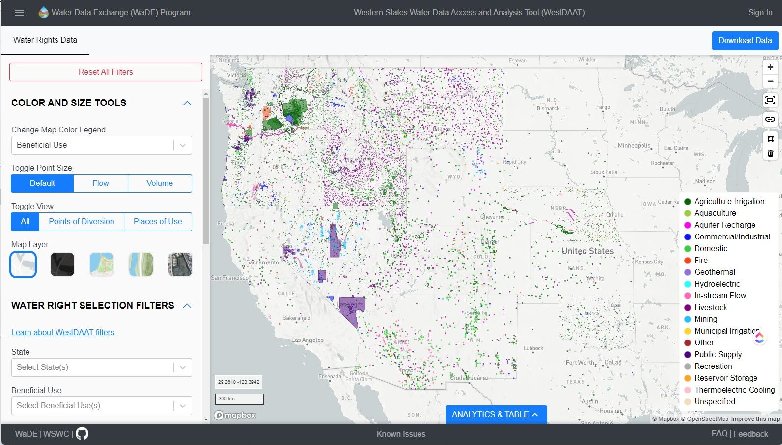
Now, for the first time, WestDAAT provides user-friendly access to data available in a machine-readable format for over 1.7 million active water rights across the West. WestDAAT also acts as a catalog of the most common metadata and provides a direct link to each state’s water rights database for more information. The data are still incomplete for some states, but the WaDE team continues to update water rights data as it becomes available in machine-readable formats. At present, WestDAAT includes a number of filters that can be used to visualize data to aid decision-making, including:
- Owner information
- Point of diversion
- Place of use
- Priority date
- Beneficial use (purpose)
- Source of supply (surface water or groundwater)
- Permitted flow or volume
- Basin or watershed
Diverse stakeholders in the pre-and post-design engagement process have widely recognized WestDAAT as an emerging tool to inform water managers in the western United States, including farmers, state engineers and natural resources department directors, river basin managers, consultants, researchers, environmental groups, and federal agencies.

Ruston Jones, Unsplash
Besides standardizing access to Western water rights data, WestDAAT integrates with the Internet of Water Coalition’s flagship technology, Geoconnex, to allow for a cross-search of its data and other national data products through consistent access protocols. WestDAAT also supports the Hydro Network-Linked Index (NLDI) tool which spatially indexes water rights points of diversion and place of use, gage stations, and reservoirs to river networks. Geo-indexing such sites allows for the search and discovery of data upstream or downstream of any location on a river or stream.

Source WestDAAT public landing page.
WestDAAT in Action: Identifying Water Users in the Bear River Watershed
To understand the usefulness of this tool, let’s look at an example. The Bear River runs through the states of Utah, Wyoming, and Idaho. It is the largest contributor of flow to the Great Salt Lake, which reached record lows in 2022. As a result, Utah’s Governor Spencer Cox issued a proclamation suspending new water appropriations within the Great Salt Lake Basin, including the Bear, Jordan, Provo, and Weber River basins. Optimizing agricultural water use through more efficient practices has been identified as one way to return water savings to the Great Salt Lake.
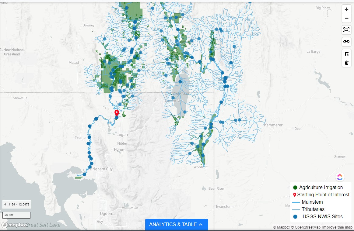
In a case like this, WestDAAT NLDI implementation can be used to query and visualize surface water rights permitted for beneficial use by agriculture (the largest water user) with early priority dates, such as those older than 1900 (indicating senior water rights), along with United States Geological Survey (USGS) gage stations in the Bear River Watershed. The NLDI tool can be used to query all permitted upstream points of diversion and places of use (up to 500 kilometers) along the Bear River above an example location in Amalga, Utah (located in Cache County), which meanders through Idaho and Wyoming, and back to Utah where it originates on the north slope of the Uintah Mountains.

Surface water rights for agriculture beneficial use with a priority date older than 1900 along with USGS Gage stations in the Bear River Watershed spanning Utah, Idaho, and Wyoming, a major tributary to the Great Salt Lake (downstream). View live in WestDAAT.
The results also show all points of diversion below Amalga, Utah, downstream to the Great Salt Lake. Users can select any water right across the three states, view related information, and visit the state water right landing page for that water right. Because of the integration with NLDI, users can click at any USGS gage station, such as the “Bear River at Idaho-Utah State Line.” The integration allows WestDAAT to access both permitted diversion data (either flow or volume) for water rights in three states and available water supplies through USGS streamflow data.

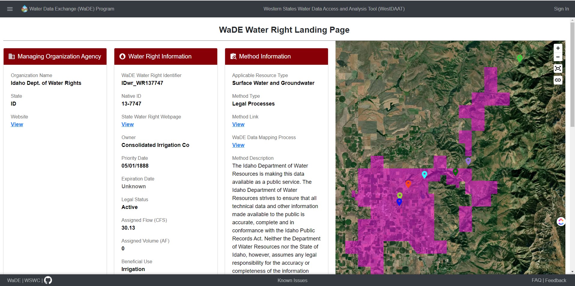
Major agriculture water right for a canal company with its service area boundary and point of diversion on the Bear River in Idaho. View the water right landing page.
Upcoming Enhancements for Even Smarter Water Management
While the WaDE team will continue to maintain and update WestDAAT and its water rights data over time, the team is planning for major upcoming additions to enhance its utility. Those additions are part of WaDE’s focus and have been requested by stakeholders.
First, WaDE will work to provide access to new water datasets, including:
- Regulatory and policy overlays that provide a spatial and descriptive context of regulations affecting water rights and water use across the West,
- Historic water withdrawals at points of diversion, where available, and
- State-operated reservoir and streamgage data.
Second, the team will focus on including data on evapotranspiration and actual consumptive use, building a Water Conservation Tool extension to help users estimate potential water savings from alternative agricultural water conservation measures using OpenET. This tool for mapping evapotranspiration and calculating consumptive water use at a regional or field scale relies on technology and data developed by the National Aeronautics and Space Administration (NASA).
This proposed tool could be of help to programs such as the Upper Colorado River Commission System Conservation Pilot Program. In 2023, the Upper Colorado River Commission (UCRC), with funding from the U.S. Bureau of Reclamation, offered compensation for water-saving measures to select applicants as part of their System Conservation Pilot Program (SCPP). UCRC staff and commissioners have highlighted the difficulty inherent in soliciting and evaluating applications as farmers faced challenges in submitting applications and UCRC staff in evaluating them given the fluid nature of proposed operational savings from fallowing different parcels, practicing deficit irrigation, or switching crops.
As states, water rights holders, other agencies, stakeholders, researchers, and communities explore the use of this tool, its capacity to revolutionize decision-making and foster sustainable water stewardship will become ever clearer.
The process involves sharing water rights and geospatial information, estimating existing and past consumptive water use and potential savings using OpenET. Separately an applicant and the Commission, with Bureau of Reclamation oversight, then sought to determine fair compensation for the foregone water use. While it’s uncertain if UCRC will fund more SCPP actions again, an extension of WestDAAT to include data on evapotranspiration and consumptive water use would be invaluable. Such a water conservation tool would be scalable westside. The tool could support conservation activities, including water marketing and banking, in other drought-affected and stressed river basins.
Accessing Water Data Across Western States
In a time of intensifying water scarcity and heightened demand for water resources in the western United States, WestDAAT is seeking to facilitate a transformation in western water management practices by encouraging conservation and simplifying access to data essential to future water marketing transactions. As states, water rights holders, other agencies, stakeholders, researchers, and communities explore the use of this tool, its capacity to revolutionize decision-making and foster sustainable water stewardship will become ever clearer.
Through WestDAAT, the Western States Water Council has brought the power of data management technology and collaboration to the forefront of water management, steering us towards a horizon where data-driven insights pave the way for a more resilient and equitable water future.
Photo Credits
Header Photo: Donald Giannatti, Unsplash
